How Roads, Expressways, and Transport Corridors Shape Property Values in Nairobi
The Nairobi Expressway, Western Bypass, and expanded ring roads have redrawn the property investment map. Here is how arterial transport corridors dictate commuter rental demand, land values, and commercial node formation.

In Nairobi, time is the ultimate luxury. Anyone who has sat in stationary traffic along Uhuru Highway, Ngong Road, or Waiyaki Way during an evening downpour understands that a home geographic distance in kilometres is almost irrelevant. What matters is transit time, accessibility resilience, and the quality of the transport infrastructure connecting you to your daily life.
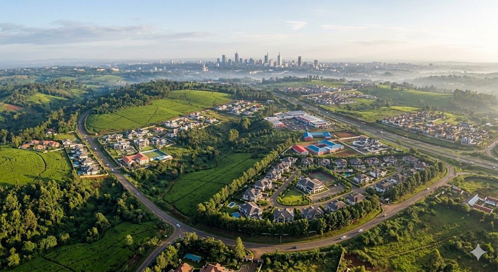
Over the past decade, major infrastructure investments: the Nairobi Expressway, the Southern, Northern, Eastern, and Western Bypasses, and modernized radial ring roads: have redrawn Nairobi real estate topography. Locations that were once considered distant peripheries have transformed into dynamic residential nodes, while established enclaves have evolved into high-density commercial corridors.
This strategic analysis explores how transport corridors dictate property appreciation, tenant absorption, and commercial expansion across Nairobi, providing a structured framework for evaluating infrastructure proximity.
Key Takeaways
- 01.Physical distance in Nairobi is secondary to transit friction; travel time dictates tenant demand and residential rental premiums.
- 02.The Nairobi Expressway structurally separated international corporate and airport transit from local city traffic, cementing Westlands as East Africa premier gateway.
- 03.The complete 4-Bypass orbital ring enabled seamless inter-suburban mobility, decoupling residential growth from CBD dependence.
- 04.Highway proximity delivers commercial land value growth but requires careful building orientation to mitigate residential acoustic and acoustic pollution.
- 05.Always evaluate the last-mile access road: an apartment tower on prime infrastructure loses rental appeal if the final 200 metres is unpaved red mud.
1. The Expressway Effect: Re-Centering the Metropolitan Core
The commissioning of the 27-kilometer elevated Nairobi Expressway fundamentally shifted Nairobi commercial and residential equilibrium. By creating an uninterrupted high-speed arterial corridor between Jomo Kenyatta International Airport (JKIA), Syokimau, the CBD, and Westlands, the Expressway effectively condensed a 90-minute commute into a 15 to 20-minute drive.
The most pronounced beneficiary of this infrastructure is Westlands. While historically a bustling commercial and retail district, the Expressway transformed Westlands into the undisputed corporate headquarters and hospitality capital of East Africa.
Nairobi Transport Infrastructure Impact Metrics
Corporate executives, diplomatic personnel, and multinational regional directors can now land at JKIA, clear immigration, and arrive at residential towers along Ring Road, Rhapta Road, or General Mathenge without encountering a single urban traffic light. This frictionless transit corridor underpins strong corporate tenancy demand and sustained rental occupancy in modern Westlands developments like Hephé Palace.
2. The Bypass Ring: Decentralizing Metropolitan Growth
Nairobi historical road network was designed around a hub-and-spoke model radiating outward from the Central Business District. This legacy design forced all vehicular traffic through the city centre, creating crippling gridlock.
The completion of Nairobi comprehensive orbital ring: comprising the Southern, Northern, Eastern, and Western Bypasses: completely restructured urban mobility:
| Transport Corridor | Primary Nodes Connected | Real Estate Transformation | Key Beneficiary Enclaves |
|---|---|---|---|
| Nairobi Expressway | JKIA, SGR Terminus, CBD, Museum Hill, Westlands | International corporate hub emergence, executive serviced apartment demand | Westlands, Parklands, Upper Hill |
| Western Bypass | Ruaka, Ndenderu, Wangige, Kikuyu, Gitaru | Accelerated high-density residential apartments, integrated outer commuter loop | Ruaka, Kitisuru, Lower Kabete, Kikuyu |
| Southern Bypass | Mombasa Road (Inland Container Depot) to Kikuyu | Shifted heavy freight logistics out of city, accelerated residential development in Karen/Langata | Karen, Langata, Kikuyu, Ngong |
| Northern Bypass | Ruaka, Two Rivers, Runda, Thika Superhighway (Ruiru) | Transformed suburban agricultural land into high-end gated estates and retail hubs | Runda, Kitisuru, Ruiru, Kiambu Road |
The bypass network enabled inter-suburban commerce without traversing the central city. A resident in Kitisuru can access the shopping hubs of Two Rivers or Village Market in minutes, or connect across the Southern Bypass to Karen, creating decentralized polycentric urban growth.
3. The Trade-Offs of Arterial Proximity: Visibility Versus Livability
While infrastructure proximity is an essential catalyst for property value, an investor must distinguish between accessibility and direct exposure.
Direct highway frontage delivers exceptional value for commercial showrooms, corporate offices, medical clinics, and mixed-use retail plazas where vehicular visibility drives revenue. However, for purely residential apartments, direct highway frontage introduces distinct livability trade-offs:
* Acoustic Noise: Heavy vehicle engine braking, siren noise, and tire friction generate continuous ambient noise (often exceeding 75 decibels) that disturbs residential peace if soundproof double-glazing is omitted.
* Air Quality and Particulates: Heavy diesel emissions along major freight corridors deposit fine particulate dust on private balconies and openable windows.
* Headlight Glare and Light Pollution: Elevated expressway lighting and vehicle headlights can sweep across lower-floor bedrooms during nighttime hours.
The Goldilocks Residential Zone
The optimal residential investment position is typically located 150 to 400 metres set back from a major arterial highway: close enough to reach the on-ramp within 2 minutes, but sheltered behind secondary residential tree canopies that absorb sound and dust.
4. The Last-Mile Reality: Secondary and Feeder Roads
A major highway corridor can elevate a neighbourhood reputation, but individual property performance is ultimately determined by last-mile connectivity.
When evaluating an apartment or residential development in areas like Kilimani or Kileleshwa, inspect the entire approach route from the primary arterial avenue:
1. Paved Tarmac vs Graded Earth: Is the approach road fully paved with storm drainage, or will monsoon rains turn the final 300 metres into an impassable mud track that damages executive sedans?
2. Street Lighting and Security: Is the access street illuminated by functional County or resident-funded solar streetlights, or is it dark and hazardous for pedestrian evening walks?
3. Road Reserve Width: Is the road wide enough for two vehicles to pass comfortably alongside roadside parking, or is it a narrow single-lane bottleneck that causes daily morning gridlock?
5. Investing Along Nairobi Infrastructure Growth Vectors
Successful real estate investing involves anticipating infrastructure completion rather than chasing speculative rumors. When you invest along confirmed, fully funded transport corridors, you align your capital with the fundamental structural growth of Nairobi.
At Zuri Estates, our location intelligence models track road construction gazettements, utility trunk line expansions, and commuter mobility metrics to identify residential developments with enduring accessibility advantages.
Explore our curated selection of properties situated along Nairobi premier infrastructure corridors in Westlands, Kilimani, and Lower Kabete, or connect with our advisory team to discuss location-driven investment strategies.
Zuri Estates Team
Property Advisory & Client Coordination
The Zuri Estates Team provides independent property guidance, market intelligence, and acquisition support across Nairobi and the Kenyan Coast. Operating from our Kilimani offices, our desk coordinates developer audits, physical site inspections, and legal conveyancing for homebuyers and investors.

Antony Baragu
Real estate strategist
This article has been reviewed by Antony Baragu to ensure the accuracy, completeness, and validity of all market metrics, property details, and investment guidance.
Related Residences, Developments & Neighbourhoods

KILIMANI · RIARA ROAD, OPPOSITE THE JUNCTION MALL, KILIMANI, NAIROBI
1 Bedroom Residence at Golden Apple Residence Kilimani
Calibrated 1-Bedroom Urban Suite with Deep Balcony Directly Opposite The Junction Mall

KILIMANI · RIARA ROAD, OPPOSITE THE JUNCTION MALL, KILIMANI, NAIROBI
1 Bedroom plus Study Executive Residence at Golden Apple Residence Kilimani
Generous 85 SQM Executive Suite with Dedicated Home Office Alcove Opposite The Junction Mall

Westlands · Ring Road, Opposite The Oval, Westlands, Nairobi
Hephé Palace
Nairobi's Dual-Horizon Crown: Where 25 Storeys of Architectural Mastery Meet Karura Forest Serenity

Kilimani · Riara Road, Opposite The Junction Mall, Kilimani, Nairobi
Golden Apple Residence
Kilimani's Urban Benchmark: Twin-Tower Sophistication Directly Opposite The Junction Mall

Kiambu · Lower Kabete, Kiambu, Kenya
ASTRA BAY Residences
Smart Living. Affordable Investment. Exceptional Value.
Featured Neighbourhood
Westlands
Nairobi’s premier commercial and luxury residential district with exceptional investment potential.
Featured Neighbourhood
Kilimani
Nairobi's vibrant apartment district with exceptional rental demand and investment potential.
Featured Neighbourhood
Kitisuru
Exclusive Green Living with Luxury Homes & Privacy